THE MAZE
These were taken on our recent week-long excursion into the MAZE district of Canyonlands National Park, outside of Moab, Utah, with good friends NE and DJ. Picture rugged abyssal canyons chiseled from Martianesque red sandstone, soaring rock architecture and perfect desert solitude. The Maze is by far the most remote section of the park, accessible only by boat or a day-long ride down a rutted and rocky (modified 4wd-only) trail. As you can see, we opted for the water access, a 50-60 mile jet-boat ride down the Colorado river. Although the boat required a STEEP hike out of the river basin (1200' in 1.2 miles), and 2 frigid 2.5-hour boat rides, it was really our only option. Unfortunately, being the desert and all, we had to pack in most of our water by jug and backpack adding an additional 150 lbs. or so to our collective burden. Worth it? Oh yeah...

The so-called "jet boat" that carried us to our desert paradise, complete with prototypical Moab "burnout" at the helm.
("this...is like my 19th season...dude")

The ladies kicking off the ascent out of the river basin with 10g water jug in tow. (This arrangement didn't last very long..)

After a few miles of hiking through the desert, we came to the MAZE threshold. Below this white-rim sandstone layer lies an elaborate labyrinth of canyons, and our luxury accomodations for the next week.

Shot looking out from our first campsite after descending below the white-rim and into the MAZE.

What?! I didn't know they wuz' thugz' in 'da MAZE?

At the top of the pic, sitting atop the white-rim sandstone, are the "chocolate drops," some of the most prominent rock features in the Maze. They're actually just large sections of rock that have yet to erode, despite the geological carnage all around them.

[Insert your own caption here]

This is the "Harvest Scene," supposedly Native American pictographs depicting the Harvest. Some say Native Americans; I say space aliens. I mean look at the striped one in the middle..what is that??

Resting in a Canyon. Waiting for The Flood.

We were also shooting a l'Oreal commercial.

A few miles down "Horse Canyon." Notice AE and DJ kicked back on the slickrock.

WATER!? Actually, we found water in a few places..Who knew?
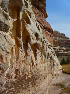
Some natural rock art. Notice NAE at the other end of the wall.

Yonic sandscapes.


These three pics were taken from the base of the famous "chocolate drops." Amazingly, we managed to find a steep and broken (off-map) route up one of the canyon walls to stand at their base. Not a bad view back down into the MAZE.

Chillin' out, maxin', relaxin' all cool, down by the water ditch.

Shadow monsters fighting on the sandstone.


These two were taken during a nice sunset.

Desert woodsnakes.

We all climbed a rock wall about 40-50' to this ledge for the sunset. This canyon is adjacent to the only campsite we inhabited for more than one night.


These three pics were taken after ascending from the depths of the Maze proper up to the white-rim sandstone layer during a snowstorm.

Nice spring color...blood red.

This is a picture of a piece of the "dollhouse" formation. Our last campsite was located in the rock opening on the left side of the pic. Notice NE and DJ walking in front of the rocks.

Some crazy fool crawling around on rocks.

and so it goes...
posted by jal at
8:58 PM
|
0 Comments
![]()


